Apayao Province: Adventure Destination

Leave a comment

In my books, Apayao is a top adventure destination. It is so raw that very few travelers venture into this northermost Cordillera province. Admittedly not an easy destination. But its remoteness adds to the adventure.


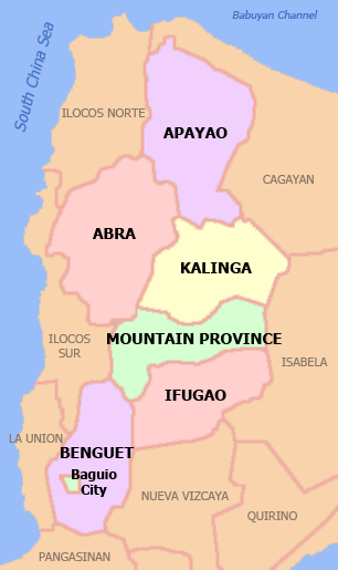
Apayao is bounded on the north and on the east by Cagayan. That is why it was, for a time, part of Cagayan. To its west is Ilocos and Abra. To the south is the province of Kalinga which was, also for a time, part of the Kalinga-Apayao province.

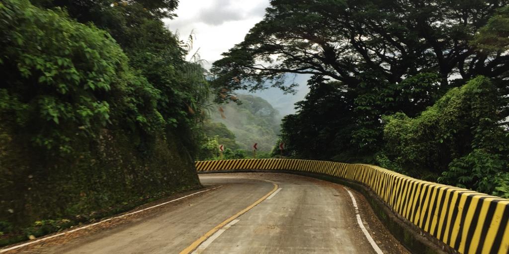
One would think that the asy access would be from Ilocos. There is none. Or from Abra. Think again. Apayao is accessed via Cagayan Valley, from the toen of Pamplona, in particular.

Thus, the adventurous visitor will have to travel all the way to Pagudpud in Ilocos Norte, cross Patapat, and drive on to the Cagayan towns of Sta Praxedes, Claveria, Sanchez Mira, and Pamplona. The junction in Pamplona leads to the first and most progressive town of Luna, Apayao.

One must make arrangements for accommodations before traveling to Apayao as there are not many. Again, that is characteristic of places where one goes on an adventure.

PLACES TO SEE

Marag Valley  is a haven for adventure travelers. Proceed to the Tourism Center in Marag Valley which is easy to find because it is within the barangay’s basketball court. Make arrangements to tour the Dupag Rock Formations, the Hanging Bridge, and the Manacota Underground River.

Dupag Rock Formation

If you are extremely fit and athletic, take the hard route. As for me, I felt that the easy route was actually hard. Wear shoes or sandals with great grip and traction as the rocks could be slippery. Do not go without a guide, as you will need him/them as human ladders.

The rock formations are accessed after crossing a shallow river.


Hanging Bridge

Not quite an adventure, but definitely a must see, even just for photography. A hut on the foot of the bridge serves as Visitors Center. List down, and make a donation. You can also arrange a picnic on a floating hut on the river.


Manacota Underground River

This is, to me, the better one of the two underground rivers in Apayao. Hike for 1.5 kilometers, crossing the same river 7x moving from one side of the river to the other, because in some parts the other end would be rocks and boulders where you can not hike. One river crossing would be nearly waist deep. Make sure you wear quick-dry shirts and shorts

Second river crossing was waist deep. And 5 more river crossings after this.

The reward from the long hike is the beautiful mouth of the river. Going in is even more pleasurable, as the narrow boat navigates in between rocks and boulders INSIDE THE CAVE. No this is not like Puerto Princesa.

The end of the underground river cruise is a beautiful spot that looks like paradise. You may want to swim there, or just stay to immerse in the beauty of nature.

Lussok Underground River

This is easier to access. We parked our 4×4 right into the grounds where the tourism desk is. There is also a toilet for visitors here. Access is easier as there is no hike, but the roadworks have not been completed so we drove our 4X4 onto a shallow river and muddy roads. 

The cruise into the cave is steadier, as the boat has a balancer (bamboo poles on its side, but not really outriggers. It was so steady the guide stood on the other end of the boat. 

Start point for spelunking

Pudtol Ruins

This is found behind the Municipal Hall of Pudtol, within the school compund, right beside the church. This was an old Spanisg church built with the intention of Christianizing the indigenous Isnegs. Another church ruins can be found in Mataguisi, a different barangay in Pudtol.

Where to Stay

Star Jewel
Hands down, it will have to be Star Jewel. The proprietor, Josefina, is a retired nurse. Basic accommodations, but nice and clean, and airconditioned. meals can be arranged. The dining room is folksy, and there is a videoke for free use of guests.


Another Option
Big groups may want to stay at the cottages operated by the Tourism Office. Each cottage can have as many as 10pax for P2,500 a night. There are many such cottages, each one with its own dining room and a living area.


Contact the Toursim office thru their facebook page
https://www.facebook.com/apayaotourismoffice/


Manacota Underground River in Apayao

4 Comments

There are two (2) underground rivers I visited in Apayao. Lussok and Manacota. For some reason, Lussok is more popular. As for me, Manacota is a better choice if one has to see only one.

Manacota is within the Marag Valley tourism package, which included the acsent to the Dupag Rock Formations and the Hanging Bridge.

To get to the mouth of the cave, one has to hike for 1.5 kilometers and cross the same river seven times (7X). Why, you might ask, must anyone cross the same river 7x? That is because in some parts, the edge of the river would be rocks and boulders you can not walk on, and so you must cross. Repeat this scenario as many times and you end up crossing the river 7x. Alas, I thought it was more than 7, and the guide said they were not counting just getting wet walking in the river, on its sides. Just crossing from one side to the other is 7x.

Start of the trek


First river crossing, thru a small dam


Second river crossing was waist deep. And 5 more river crossings after this.

At the end of the river crossings, we saw this sign that enjoins visitors to preserve Manacota.


The fatigue from walking and crossing rivers is compensated by the beauty of the destination. And it was still just the mouth of the cave. So serene. beautiful.

We then boarded the boat without outriggers into the cave. This was realyy some adventure. The boat without outriggers was navigating thru rocks and boulders inside the cave. Some passages were so narrow it was just enough for the width of the boat.

The end point was even more worth it. It looked like paradise. The waters were stronger and the boat had to be anchored on one side of the cave to protect it from the rushing waters. We got off and saw some portions of the river so clear, so clean, and actually inviting guests for a swim. Perfect spot that we wished we could stay there longer and gave a picnic.


But we had to go back as another set of visitors had to use the boat for the same beautiful experience.

From the cave and into its mouth again

The trek back was easier, even as we were more tired. We were looking forward to a sumptuous second lunch (hahaha) that we arranged for the wife of the barangay captain to cook for us. Surely, some nourishment after this tiring but worthwhile adventure.


our guides, and the barangay captain

Pudtol Church Ruins in Apayao

2 Comments

Pudtol is about 20 minutes drive from Luna town proper.

Do not ask the locals about the ruins. Chances are they are unmindful of its significance. To get there, ask instead for directions to the Pudtol Municipal Hall, and you will find a church and school at the back. On the right side of the church are the ruins.

From online sources, the church  was built in the 1600’s by Spanish missionaries to convert the locals, known as Isnegs, to Christianity.  Today, the Isnegs comprise a good majority of the indigenous people of the province of Apayao, even if about half of its population are Ilocanos. At some point, this church was abandoned, and eventually deteriorated. Today, only the ruins tell of that story about early attempts to Christianize the indigenous tribes of the cordilleras.

Within Pudtol town, there are two church ruins – – the other one in Mataguisi. I actually went to Pudtol as a side trip on my way to Kabugao, and for some reson missed mataguisi, in spite of seeing the Mataguisi signs early on.

Pudtol can be visited on its own from Luna town. But if one is on his way to Kabugao or to Kalinga Province, then Pudtol will be an easy side trip since it will be on the way.

Hanging Bridge in Marag Valley

Leave a comment

Yes, it is but a bridge. But in beautiful Marag Valley, the hanging bridge takes on a special persona. Because of the general feel of the river and the fields, crossing the hanging bridge becomes an urge. I am told that single motorbikes even cross the bridge  – – I can not imagine how, but I believe.

There is a small hut that serves as a visitor’s center. One needs to register, and make a donation. Gladly.

Not much to say, and I think the photos will invite you to see the bridge. Or maybe have a picnic on a floating hut.

Have a picnic on this hut that can float into the clean waters of the river


Register, and drop something in the Donation Box for the maintenance and improvement of the hanging bridge


Dupag Rock Formations in Marag Valley, Apayao

4 Comments

Bar none, this is the top draw when any traveler goes to Apayao.

First, for its sheer beauty. Second, for the challenge one has to take to conquer the rocks.

I am 61 years old, and a regular adventure traveler. And so the guide asked whether I am up to climbing Dupag using the hard route. Instinct told me to take the easy route.

The easy route was not at all easy. Even while I was blessed with good weather (a group of friends went 2 weeks earlier but did not make it to the rocks because of incessant rains), the climb was still difficult because the rocks were still rather slippery. I was wearing a good pair of sandals, but for some reason, my soles would slip. Thus, I had to do it more slowly, hanging on to trees and shrubs along the way, and clinging on to rock surfaces.


Higher into the climb, I was beginning to ask myself if I could make it, or retreat and go back down. But heck, I was there already, so I persisted and climbed some more. No harness. And the climb meant inserting my feet, usually just my toes, into tiny crevices of the rocks. And holding fast to the sides of two rocks, if not to the sharp ends of the top surfaces.

Moving from one section to the next is a bigger challenge. To go beyond one rock that looked like a giant blade into the next rock, one could fall. But our able guide perched himself between two rocks and asked me to use his thighs as a step. OMG! If he fell from my weight, we would both fall down. On top of that, I had to hang on for dear life to the top surface of another rock while stepping on his thighs. But I made it to the next spot.

I had lots of water for sustenance. And in many parts, I felt like the wind wasn’t at all blowing, the leaves on the fields still, and so I was gasping for breath, needing oxygen. I fanned myself using my baseball cap. And was unashamed to tell the guide I needed to rest to recover so I can go on.

Finally we made it. Success !

With the difficulty and all, I think I will do it again when I re-visit Apayao. Especially since I have made it once, and know exactly what to expect the next time.

How to get there

From Luna town, visit the Tourism Center in Marag, near the basketball court, about 15-20 minutes from Luna town center. Register and they will provide a guide and head gear for safety.


From the visitor center, we were guide to Dupag.

Vehicles are parked at a point before everyone has to cross a shallow river. There is a small hut afterwards, but it served its purpose better on our return, to rest a little bit.

Rest Area

Somewhere near the rest area was a hut where an old man lived, and he showed us a lambanog (fermented coconut wine) with ginseng and real cobra inside.

a real COBRA drink

Lunch

Had lunch in a small carinderia near the basketball court.

VISIT MARAG VALLEY

There are other attractions within Marag Valley. Like the Hanging Bridge, and the Manacota Underground River. Will be writing about these attractions, too. Meanwhile, I had to take a souvenir shot to prove my conquest of Dupag.

Lussok Cave and Underground River, Luna Apayao

Leave a comment

Prior to traveling to Apayao, I researched on “must see” places and Lussok is one of the Top 3. Thus, I made sure this was going to be part of my itinerary.

LUNA, APAYAO
This cave and underground river system is in the town of Luna, the first town one will hit when traveling to Apayao from Cagayan Valley, the easiest access to this province. Thus, Luna town has become the de facto provincial capital. In fact, the government center has moved from the official capital town of Kabugao to Luna.

On the rocky slope of Barangay Dagupan one will find this  this multi-chamber cave  with beautiful centuries-old stalactites and stalagmites, with crystals embedded. Thus Lussok is also called Lussok Crystal Caves.  The visit is via a boat without outriggers, on calm and placid waters from the opening of the river unto the end.


Our boat had a boatman and a guide who brought in a flashlight, admittedly rather weak, but enough to show us the images created by the rock formations – the Blessed Virgin Mary, fruits and veges, animals, and faces . The water was so still our guide was standing on the front end of the boat.


IMG_4577

IMG_4580

SPELUNKING

The Lussok caving adventure has three options for spelunking, with easy, moderate and hard routes.  The trail eventually leads to a bridge  above the entrance to the caves, visible to everyone going into the cave by boat.

Start point for spelunking

ACCESS TO LUSSOK

I understand from previous stories that Lussok was difficult to access. But with roads done, this cave system will soon be more accessible. On my visit, we drove our 4X4 all the way to the compound where they accept visitors to the cave. But that was after traversing a shallow river and muddy roads because the road has not been completed. I assume that in the next many months, Lussok will be most accessible.


The Visitor Center


literally: Apayao, Be Proud of It (Apayao: Ipagmalaki)


Star Jewel Lodge in Apayao

1 Comment

It is a jewel. And I am happy to have found it.

Star Jewel is, to me, the best place to stay in Apayao. It is in Luna town, the first town the traveler will hit when entering Apayao via the usual and fastest way – –  from Pamplona in Cagayan Valley.


First town from Cagayan Valley

The place is comfortable, homey, and friendly. No frills. No fuzz. I rate it 5 stars not because of its rooms nor its facilities. No, no way it compares with the best hotels. But it is perfect for travelers like me wanting to experience the rugged beauty of the province of Tuguegarao.

It is a nice place to come home to after rock climbing, after crossing rivers, after spelunking or just taking boat rides thru underground rivers. It is a nice place to have a beer, and a chat with other guests with the same passion and interest. And for warm, small talk with the owner, retired nurse Josefina, and her staff.

owner Josefina, retired nurse

Josefina tells me that when she started the business, it was billed as “homestay”. Because that was how the hospitality business started in Apayao when there were only a few visitors, and no real hotels. Realizing that homestays mean accommodating visitors into your own home, and because she has built private rooms for guests, she then called it, appropriately, a lodge. Star Jewel Lodge. And because of her facilities, the lodge is accredited by the Department of Tourism.

I arrived around 7pm because travel to Apayao is really long. Travelers from Manila will have to take NLEX SCTEX TPLEX and drive on all the way to Pagudpud and to the  Cagayan Valley towns of Sta Praxedes, Claveria, Sanchez Mira, and Pamplona. It is in Pamplona where there is a junction to Apayao with Luna as the first town.

The late arrival, tired from travel, was met with a pleasant dinner of crabs and adobo, plus seaweeds salad, and bananas for dessert.

My room was clean and nice, I mean nicer than I expected since Apayao is a poor and remote province. My room had aircondtioning, a nice bed (actually 2 beds), a proper toilet with shower and toiletries.


The common dining area was simple and folksy, complete with a videoke for visitors, at no extra charge. Coffee is always available and one only needs to get some from the thermos. Drinking water is purified.

Breakfast can also be arranged, as I did.

Exploring Apayao’s rock formations, underground rivers and other interesting spots will necessitae staying at Star Jewel at least two nights. Thus, plan your trip well, and book the nights you will need. Because you might otherwise have to stay somewhere with less than the comforts and atmosphere of Star Jewel.

Josefina does not always have her mobile phone with her. So you need to persevere and keep calling. Better yet, send her a text message so you know you get your reservation across, and continue to call to confirm, if she hasn’t returned the call.

As I checked out after 2 nights for my long journey to Kalinga, Josefina gave me plenty of suman (rice cakes)  as my baon. Wonderful, thoughtful lady indeed. 

I felt so enamored I wanted to review them on tripadvisor, but they were not listed. So I listed Star Jewel on tripadvisor and, hopefully, they will be so listed. I will be back to Star Jewel. For the suman. And for the warm welcome.

visit their facebook page:

https://www.facebook.com/STAR-JEWEL-LODGE-830464200351918/

Road Trip: Apayao to Kalinga

1 Comment

November 14, 2017 I posted on my facebook wall

And,  immediately, my well meaning friends who only recently visited Apayao and Kalinga gave me friendly advice:

“Ingat sa daan… expect the unexpected”

“be very careful. the road is very treacherous.”

“Via Pudtol-Kabugao-Conner-Tabuk…. yan ang tunay na adventurer….”

That is because I was going from Apayao to Kalinga on a route less traveled. My friends who recently visited, and other sets of friends who visited Apayao and Kalinga, would eventually exit from Apayao thru Cagayan Valley and enter Kalinga thru Tuguegarao.

In fact, when  I wanted to estimate the distance and travel time thru waze, the app was responding via the route always taken: exit thru Pamplona and then enter Kalinga thru Tuguegarao. Waze would not recommend the route.

Then I tried to calculate travel time to Conner, the last town in Apayao that shares boundaries with the first town of Pinukpuk in Kalinga, and waze again calculated using the entry via Tuguegarao. Made me think the roads are impassable.

Starting point: Star Jewel Lodge

A chance encounter with a guest at the lodge I was staying in made me decide to take the Apayao to Kalinga route. The gentleman is from Conner. He said the roads are good, but the concern was that there is a long stretch of mountain roads where there was no mobile signal, and where there were no homes or communities. That if something goes wrong, the traveler will be helpless.

I also asked a friend who lived in Tabuk if the road from Pinukpuk to Tabuk was good. She said yes.

And so armed with this info, I made sure I had enough water and food, just in case something goes wrong.  And off I went.

From Luna in Apayao, the next town was Pudtol. It was a good stop to take a photo of the ruins of the old church.


Ruins of an old church in Pudtol, the most visited spot on this town

From Pudtol we started ascending the mountain road that led to Kabugao, the capital of Apayao. And then to Conner, the last town.


I realized, too, that in Apayao, there are cattle ranches.


From Conner, I saw the uphill road to Kalinga, starting from the town of Pinukpuk. And then it was on to Tabuk, the capital of Kalinga.

No wonder waze points to the route via Cagayan. This is a point where Kalinga, Apayao, and Cagayan meet.


The welcome sign at PINUKPUK,  the first Kalinga town from this route.


Travelers will then have the Chico River throughout the route, all the way to Tabuk City


The roads are used to dry either rice or corn


a business establishment in Pinukpuk


Finally, TABUK

Tabuk City Hall

Travel time, including stops, was 5 hours. The roads were alternately good and bad, mostly good. The views were fantastic, and more than made up for the uncertainty, and the potential danger.

Having taken this route, I now know that, with a reliable 4X4, this road is actually easy. Exciting. And scenic.

Kalinga

2 Comments

Kalinga is a landlocked province within the Cordillera region. Prior to 1995, it was part of Kalinga Apayao. Apayao, now a separate province is north of Kalinga.

Kalinga has rugged and sloping terrain.  with mountain peaks ranging from 1,500 to 2,500 meters high. Its western side, towards the province of Abra, has sharp, crested, interlinking peaks of steep slopes, isolated flatlands, plateaus and valleys. Mount Balbalasang, a national park within the town of Balbalan is on this side.

Cordillera

IMG_4926

Mt. Balbalasang in Balbalan

Typically one goes to Kalinga and hike to the town of Buscalan to witness Wang Od, most popular for her art of tattoos. Even local and international celebrity have come to be tattooed by this now legendary woman.

But I choose to write about Kalinga and how it has been so blessed by mother nature.

RICE TERRACES

Kalinga boasts of majestic rice terraces. All over the province. In every town. Huge ones and rather small patches.

IMG_4692

IMG_4741

IMG_4690


CHICO RIVER

Chico River dominates Kalinga. It is a source of water, and a source of pride.

The most extensive river in the Cordillera region, it covers the provinces of Mountain ProvinceKalinga and Cagayan. It is referred to as a “river of life” for the Kalinga people who live on its banks, and is well known among development workers because of the Cico River Dam Project, an electric power generation project which local residents resisted for three decades before it was finally shelved in the 1980s – a landmark case study concerning ancestral domain issues in the Philippines.

It is also the most famous river for whitewater rafting. I have a set of friends who would set out for their annual whitewater adventure every year, on New Year’s day.

TABUK, the only other city in the Cordilleras after Baguio City

The capital of Kalinga is Tabuk City. It does look like any provincial city, with many hotels, restaurants and malls.


Tabuk City Hall

Within Tabuk is an interesting bridge that contrasts the old and the new.

My hotel of choice in Kalinga is Grand Zion.

Grand Zion Hotel

LUBUAGAN

A most interesting town to visit is historic Lubuagan, once the capital of Kalinga and also once the seat of the Third Philippine Republic when then president General Emilio Aguinaldo based himself in this small town for several days.  It laso had the first educational institutions in the region, and naturally had wealthier homes as it was then the trading center.

BALBALAN

Balbalan is a hard-to-reach town towards the west of Kalinga. It is famous for its rice terraces and the Balbalasang-Balbalan National Park at Mt. Balbalasang


The towns of Pasil and Tanudan are also interesting destinations for their rice terraces. However access to most towns is difficult as most roads are eroded and, therefore, muddy for the most part.


My Route to Kalinga
Most people go to Kalinga via Tuguegarao. Admittedly, this is the easiest way. But the more adventurous can also approach Kalinga from Apayao, or from Abra. The roads to and from Abra or Apayao are not recommended for those who want to take it easy. But that will be another story, and I shall be writing about my travels thru these routes less-traveled.

This welcome sign greeted me when I came from Apayao

Pasil in Kalinga

1 Comment

Pasil is a 5th class municipality in Kalinga.

My journey to Pasil started when I chanced upon a beautiful, quaint cafe by the provincial road on the way to Lubuagan, Tinglayan and Bontoc. This is Bangyan 88, a cafe/resto I am writing separately about. Found out that that spot in Pasil is practically the only point in this town that is easy to reach.


Turning right from Bangyan 88 leads to another provincial road that actually goes to Abra. The road starts as one beautiful concrete road with beautiful sceneries. 

And then the roads quickly changed. It felt like a different place.

I arrived in the barangay called Ableg where I saw a truck with locals as hitch hikers. The truck passed thru muddy dirt roads with cascading water from the mountains in certain sections.

Had t do a u-turn within a community to get to the other side of the mountain, to continue my journey. Until I got to 2 kms to the town proper.

There are stretches of concreted roads. But any traveler will have more vivid memories of how difficult the unpaved, muddy roads are to negotiate. In most parts, one wonders whether or not to go on, or just turn back.

I also saw the barangay called Balinciagao.

And maybe other barangays the signboards of which I chose to not mind, with myself concentrated on how to negotiate this extreme adventure on muddy roads.

While difficult, one is rewarded with sights of clouds covered mountains and rice terraces here and there.

The next town after Pasil, on the same road, is Balbalan. And that will be another story.